

Gin Tidridge, Independent Councillor, Bishopstoke, 17 September 2016: There is a house in Bishopstoke where each neighbouring house has been empty for some time. In Eastleigh, the total number of empties has gone up from 951 in 2014 to 988 in October 2015. The number of long term empty properties has gone from 255 to 311 over the same period. This may be only a percentage of the empty homes in the borough – if a home has furniture in it, it may be classified as a second home, not empty, even if nobody has lived there for years. With so much demand for housing, it seems incongruous that EBC may not be working to turn at least some of the long term empty properties back into homes.
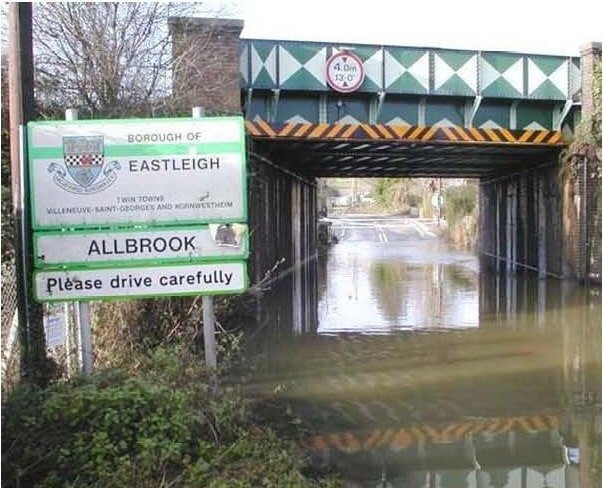
ADD UPDATE: Can this bridge cope with 30,000 more daily car journeys?
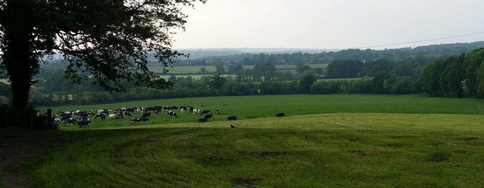
ADD UPDATE, 16 September 2016: If Eastleigh Borough Council proceed with options B and C for its Local Plan, it will build a new North Bishopstoke link road from Mortimers Lane in the east towards the M3 in the west, squeezing under this Allbrook railway bridge along the way. With the Plan’s 6,000+ new houses creating an estimated 30,000 more daily car journeys, this bridge is clearly too narrow, too low, and, as this picture shows, too prone to flooding to cope (it even causes serious traffic jams today). With no plans to do anything about it, this bridge is one factor making a mockery of the viability of options B and C.
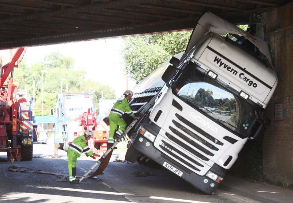
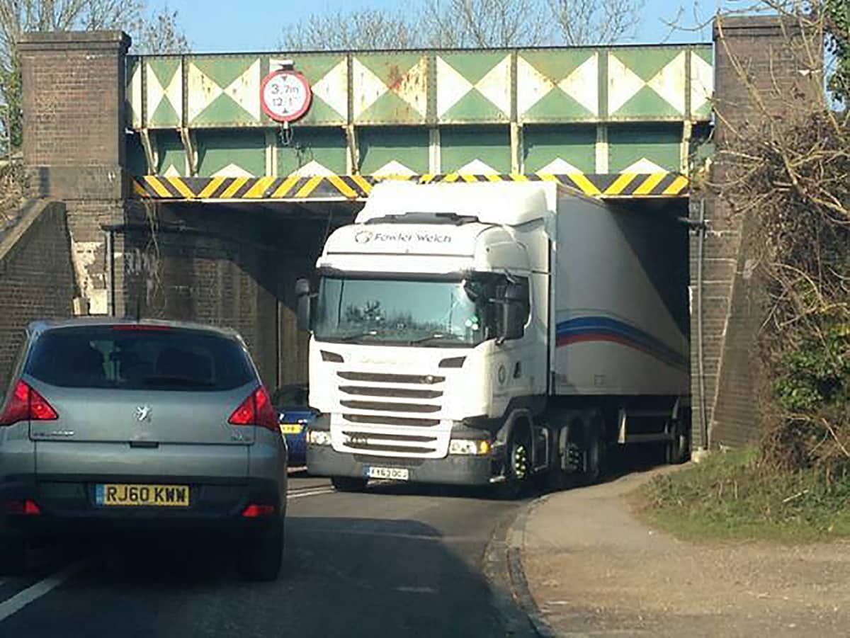
ADD UPDATE: Lorry gets stuck under higher Hampshire bridge than Allbrook
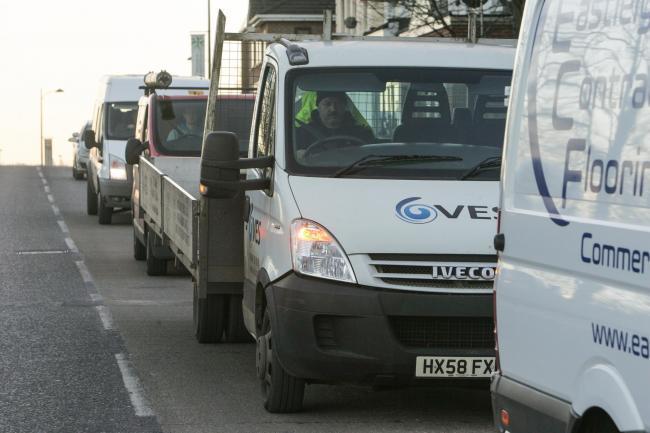
ADD UPDATE, 16 September 2016: A lorry crashed and became stuck under a railway bridge in Romsey, Hampshire, on 14 September, paralysing a town’s road network for several hours, reported the Daily Echo yesterday. Police closed the road in both directions while recovery teams launched a mission to free the stranded truck.
Locals say it is almost the 20th time in just ten years a lorry has got stuck under the bridge crippling roads around local homes, and say ‘lives are being put at risk’.
This bridge has 14’3” of headroom, whereas the Allbrook bridge which is at the west end of Eastleigh Borough Council (EBC)’s new link road for options B and C, has only 12’1” of headroom. Lorries have on a number of occasions also got stuck under the Allbrook bridge, causing chaos, and with no plans to heighten the bridge, which also floods, how would it cope with the 30,000 more daily car journeys and delivery lorries the 6,000+ houses EBC are building in the area would generate?
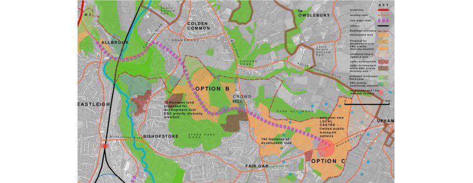
Architect illustrates sustainability of options D and E vs B and C
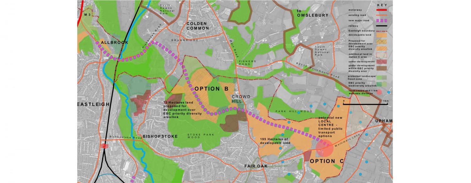
David Ashe, 9 September 2016: As you will see in this map of options B and C, this area would comprise 195 hectares (482 acres) of housing development, mostly located between Crowd Hill and Mortimers Lane, with small infill sites around Allbrook. In addition, the developers Highwood propose 72 hectares (178 acres) of development on EBC designated ‘priority diversity areas’. Developments are already underway building in these supposedly protected areas. The plan necessitates a 6.5 kilometre-long distributor road running from Mortimers Lane to the M3 at Allbrook, through some of the prettiest green fields in Hampshire. The development would be broken up by 16 Sites of Importance for Nature Conservation, and would stretch all the way up to the South Downs National Park at Lower Upham, all of which would be put at risk by putting houses right next door to them.
The distributor road would use the existing bridge at Allbrook. Despite the fact that lorries regularly get jammed under this bridge and the bridge floods, there are no plans to address these problems.
Further, the best option for a local centre for the development would be on Mortimers Lane. Even here only a minority of the total number of homes would be within 1 kilometre (walkable distance) of the local centre, making this development highly car dependent, with no public transport other than buses to connect it to Eastleigh or other centres.
Meanwhile, as shown in this map, options D and E would comprise 240 hectares (593 acres) of development clustered around a new local centre with a new railway station (proposed by the Solent LEP in its latest report on strategic investment) connecting direct to Eastleigh and, with the LEP’s proposed new rail loop, to central Southampton. Most of the new homes would be within 1 kilometre (walkable distance) of the local centre. A new road running direct to Eastleigh would provide a South Bishopstoke bypass, and there is the potential to provide the missing Junction 6 on the M27.
A landscaped buffer running north of the M27 would avoid coalescence with West End and there is also scope for a landscape buffer strip south of Fair Oak / Bishopstoke. Meanwhile, a biodiversity corridor would link the Itchen Valley Country Park to other Sites of Importance for Nature Conversation in the area.
ADD UPDATE: Upham & Owlesbury residents: Village Meeting, 7.30pm, 29 September 2016, Upham School Hall
ADD UPDATE, 9 September 2016: We will be holding a Village Meeting for Upham and Owlesbury residents (only, due to capacity restrictions) on the Eastleigh Local Plan 2016-36 at 7.30pm on Thursday 29 September 2016 in Upham School Hall. If options B and C go ahead, we will have a new settlement of over 6,000 new homes, twice the size of Bishop’s Waltham, on the unspoilt countryside south of Upham, between Fair Oak and Bishopstoke and reaching right up to the boundaries of the South Downs National Park. This could result in 30,000 extra car journeys each day, creating dangerous traffic levels on our local lanes. We believe that this development is neither deliverable nor sustainable but, if we do nothing, it will happen. Come to the meeting to hear how the planning process is progressing, what happens next and how, together, we can fight this proposal. Refreshments available. Parking limited so please walk or share cars where possible.

ADD UPDATE: Surge in interest means our campaign needs YOU!
ADD UPDATE, 7 September 2016: Our new website, and recent postings, have led to a massive surge in interest in our campaign to ensure Eastleigh Borough Council chooses the right Local Plan. We now urgently need more volunteers to staff our campaign and maintain this remarkable momentum. If you have experience in, or would like to turn your hand to helping us with, issues like digital media, PR, journalism, fundraising, research, planning, the law, leafleting or indeed anything you think we might need, please get in touch today. You would join a stimulating and fun group, pulling together for a cause we’re passionate about, and we would love to have you board!
New video emphasises shocking scale of options B and C
Rob Byrne, 3 September 2016: In this brilliant new video, Rob Byrne reveals the truly shocking scale of Eastleigh Borough Council’s development plans north of Bishopstoke, so-called options B and C. From Lower Upham and the South Downs in the east to the motorway junction at Chandler’s Ford in the west. Starting with East Horton Golf Club, at the far south-eastern extremity of option C, which would be completely built on, Rob takes us through an extremely disturbing journey through what – for now – remains some of the UK’s finest countryside. Help us prevent this outrage now!
Mims Davies MP supports vital infrastructure petition
Eastleigh MP Mims Davies has backed a petition by local activists demanding the Chickenhall Link Road is built.
Mims met with Councillor Gin Tidridge, the petition’s coordinator from Bishopstoke Parish Council, yesterday to give her support to pressure group Action Against Destructive Development (ADD) in its campaign to “Get The Chickenhall Lane Link Road Moving” which has been supported by over 400 local residents.
The petition is asking the leaders of Eastleigh Borough Council, the Solent LEP and Hampshire County Council, as well as the Chancellor and Ministry for Transport, to back Mims Davies’s continuing call for this long required road to be built.
CPRE update on its work with ADD
CPRE Hampshire, 31 August 2016: Since a fairly frustrating Eastleigh Borough Council (EBC) meeting at the end of July, CPRE Hampshire has been working alongside ADD on the next steps to fight options B and C. CPRE asks you take the time to sign the petition to “Get the Chickenhall Lane Link Road Moving” – see link in article. If this road was built it would open up a number of more appropriate development options for the council.
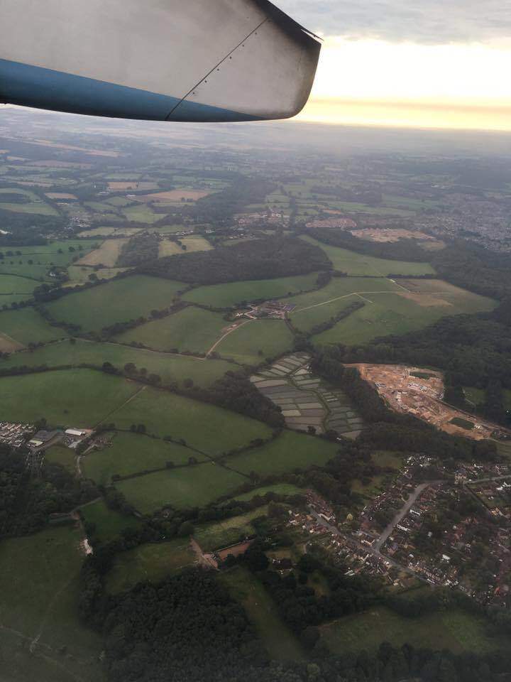
Aerial photo shows magnitude of B and C development
Chris Tomkins/Rob Byrne, 29 August 2016: This great aerial photo by Chris Tomkins shows the extent of the destruction that options B and C would cause. Stoke Common Road is at the bottom of the picture, with Upper Barn and Crowdhill Copses in the middle of the picture, and Stoke Park Woods on the right. At the far top is the countryside north of Mortimer Lane, Fair Oak heading towards Upham. It’s important to realise the open countryside you see is only two thirds of the total ‘new town’ Eastleigh Borough Council is thought to be planning as Allbrook, Highbridge and the M3 are not visible.