Blog

ADD UPDATE: Plan for new station at Allington Lane strengthens case for D and E

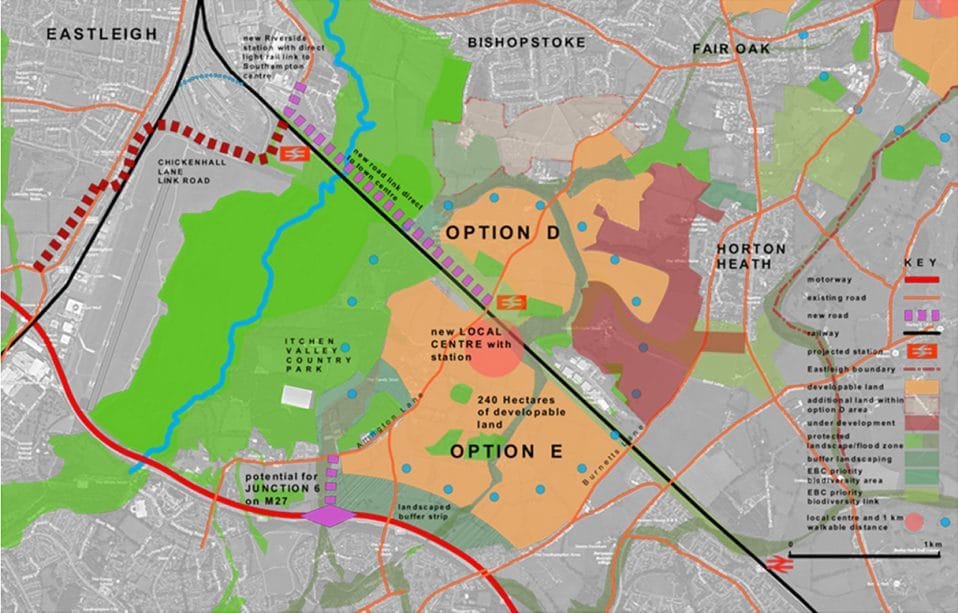
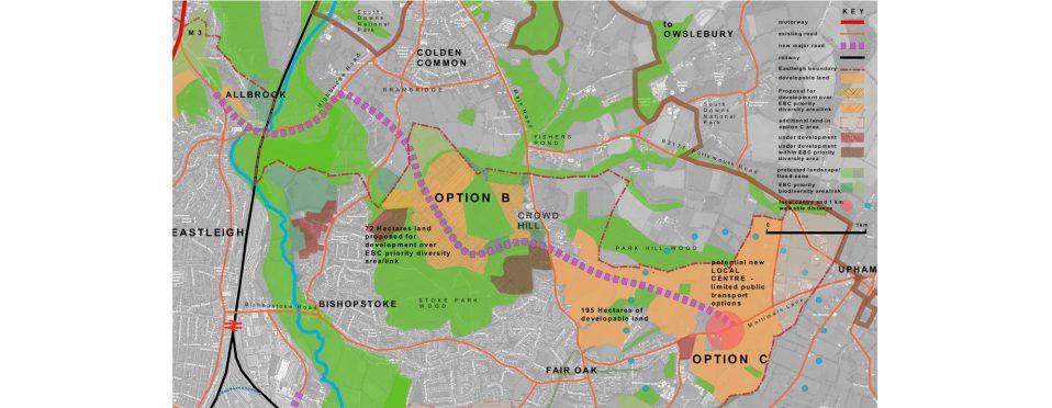
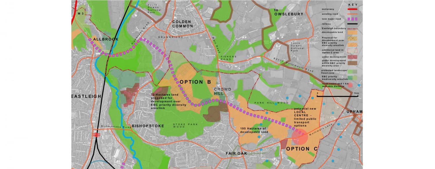
ADD UPDATE, 1 November 2016: Strengthening the case for options D and E of Eastleigh Borough Council (EBC)’s Local Plan (see map above) is the Solent Local Enterprise Partnership’s Solent Strategic Transport Investment Plan published in May this year.  This Plan proposes a new light rail network from the centre of Southampton, through Southampton Parkway station to Fareham.

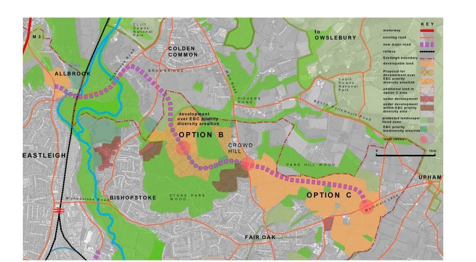
The plans show stations at Eastleigh Riverside and another central to the area of options D and E at Allington Lane.  This network would allow direct public transport for journeys to Eastleigh, Southampton and Portsmouth, and would link to the rail and air network for longer journeys.  This would do much to mitigate the increased traffic caused by the building of 6,000+ houses and would create tremendous opportunities for business growth in the area.  Options B and C, which are isolated from any public transport options, would offer no such advantages.

Past experience of new train stations in the area show how successful a new station at Allington Lane might be: Chandlers Ford Station, originally built in 1847 but closed in 1969, which cost £2.8 million to reopen in 2003, now serves a quarter of a million passengers a year. Similarly, Hedge End station, which was opened in 1990 to link that area to Eastleigh and Portsmouth, serves the extensive housing developments in that area and is now used by half a million passengers per year.

There are many reasons why options D and E are better than options B and C, the potential for a new station at Allington Lane being just one of them.  Let’s hope Eastleigh’s councillors see sense and favour the right options when they decide upon our future in December!

More

ADD UPDATE: EBC’s Local Plan delayed, exposing area to developers

ADD UPDATE, 30 September 2016: Eastleigh Borough Council (EBC)’s cabinet voted on Tuesday to delay their Local Plan process so that it does not go live until mid-2018, at least a year later than originally anticipated.

The cabinet stated, ‘Due to the need to “roll forward” the plan evidence and resulting plan policies and spatial strategy to 2036, a substantial amount of additional time and resources is required. This is necessary to ensure the most sustainable and deliverable locations for proposed development are included and justified in the Plan.

The delay is driven by EBC’s need to show their large-scale development plan of over 6,000 houses to be ‘deliverable’ to the Planning Inspector – which means more preparation is required.  The July 2016 Council Paper indicates that a large development should be investigated further – and that only two areas are being considered as locations – North Bishopstoke and Fair Oak (Options B and C) being one; Allington Lane (Options D and E) being the other. 

In our view, it may be that Cllr House has realised that he faces organised and strong opposition if North Bishopstoke and Fair Oak is included in the plan.  

This means that those of us who support the ADD campaign are in for a marathon, not a sprint.

It also means that Eastleigh is exposed to developers submitting whatever they want between now and 2018 as there is no Local Plan.  In theory, failing to get the Plan done by Spring 2017 means that the Secretary of State could opt to take the plan over – but we believe that this is unlikely.

Several ADD campaigners attended the meeting – and we exercised our right to record it as we are concerned that EBC official minutes do not detail debates or the content of public representations.

Cllr Airey said that he hadn’t realised it was ‘such a beautiful area’ and that it was ‘smothered with many footpaths’ – until he had walked through it with Rob Byrne.  Sadly, Cllr Airey’s remarks were not minuted! We hope that more councillors will take up Rob’s invitation for a guided walk so that they can see why we are so convinced that the North Bishopstoke and Fair Oak development is such a destructive idea. 

More

EBC urged to consider huge number of empty houses in borough

Gin Tidridge, Independent Councillor, Bishopstoke, 17 September 2016: There is a house in Bishopstoke where each neighbouring house has been empty for some time. In Eastleigh, the total number of empties has gone up from 951 in 2014 to 988 in October 2015. The number of long term empty properties has gone from 255 to 311 over the same period.  This may be only a percentage of the empty homes in the borough – if a home has furniture in it, it may be classified as a second home, not empty, even if nobody has lived there for years. With so much demand for housing, it seems incongruous that EBC may not be working to turn at least some of the long term empty properties back into homes.
More

ADD UPDATE: Can this bridge cope with 30,000 more daily car journeys?

ADD UPDATE, 16 September 2016: If Eastleigh Borough Council proceed with options B and C for its Local Plan, it will build a new North Bishopstoke link road from Mortimers Lane in the east towards the M3 in the west, squeezing under this Allbrook railway bridge along the way. With the Plan’s 6,000+ new houses creating an estimated 30,000 more daily car journeys, this bridge is clearly too narrow, too low, and, as this picture shows, too prone to flooding to cope (it even causes serious traffic jams today). With no plans to do anything about it, this bridge is one factor making a mockery of the viability of options B and C.

More

ADD UPDATE: Lorry gets stuck under higher Hampshire bridge than Allbrook

ADD UPDATE, 16 September 2016: A lorry crashed and became stuck under a railway bridge in Romsey, Hampshire, on 14 September, paralysing a town’s road network for several hours, reported the Daily Echo yesterday.  Police closed the road in both directions while recovery teams launched a mission to free the stranded truck.

Locals say it is almost the 20th time in just ten years a lorry has got stuck under the bridge crippling roads around local homes, and say ‘lives are being put at risk’.

This bridge has 14’3” of headroom, whereas the Allbrook bridge which is at the west end of Eastleigh Borough Council (EBC)’s new link road for options B and C, has only 12’1” of headroom.  Lorries have on a number of occasions also got stuck under the Allbrook bridge, causing chaos, and with no plans to heighten the bridge, which also floods, how would it cope with the 30,000 more daily car journeys and delivery lorries the 6,000+ houses EBC are building in the area would generate?

More

Architect illustrates sustainability of options D and E vs B and C

David Ashe, 9 September 2016: As you will see in this map of options B and C, this area would comprise 195 hectares (482 acres) of housing development, mostly located between Crowd Hill and Mortimers Lane, with small infill sites around Allbrook.  In addition, the developers Highwood propose 72 hectares (178 acres) of development on EBC designated ‘priority diversity areas’. Developments are already underway building in these supposedly protected areas.  The plan necessitates a 6.5 kilometre-long distributor road running from Mortimers Lane to the M3 at Allbrook, through some of the prettiest green fields in Hampshire.  The development would be broken up by 16 Sites of Importance for Nature Conservation, and would stretch all the way up to the South Downs National Park at Lower Upham, all of which would be put at risk by putting houses right next door to them.

The distributor road would use the existing bridge at Allbrook.  Despite the fact that lorries regularly get jammed under this bridge and the bridge floods, there are no plans to address these problems.

Further, the best option for a local centre for the development would be on Mortimers Lane.  Even here only a minority of the total number of homes would be within 1 kilometre (walkable distance) of the local centre, making this development highly car dependent, with no public transport other than buses to connect it to Eastleigh or other centres.

Meanwhile, as shown in this map, options D and E would comprise 240 hectares (593 acres) of development clustered around a new local centre with a new railway station (proposed by the Solent LEP in its latest report on strategic investment) connecting direct to Eastleigh and, with the LEP’s proposed new rail loop, to central Southampton.  Most of the new homes would be within 1 kilometre (walkable distance) of the local centre.  A new road running direct to Eastleigh would provide a South Bishopstoke bypass, and there is the potential to provide the missing Junction 6 on the M27.

A landscaped buffer running north of the M27 would avoid coalescence with West End and there is also scope for a landscape buffer strip south of Fair Oak / Bishopstoke.  Meanwhile, a biodiversity corridor would link the Itchen Valley Country Park to other Sites of Importance for Nature Conversation in the area.

More